What happened to the levees of New Orleans in 2005 — massive collapses during Hurricane Katrina, leaving most of the city underwater — could happen to fragile levees near Sacramento that protect supplies of precious fresh water to farmlands in the vast San Joaquin Valley and to most of Southern California. But in this case, it wouldn’t be a hurricane but the massive wallop of an earthquake that could bring the levees down.
That’s why UCLA earthquake experts Scott Brandenberg and Jonathan Stewart will be shaking things up in the Sacramento-San Joaquin River Delta next week, when they rev up powerful mobile field shakers to test the effects of a temblor on a levee of their own — 6-foot-tall, 40-foot-wide soil embankment they’ve built atop a base of soggy peat.
What they learn from their research will help guide decision-making at the state and federal levels before it’s too late to avert a statewide disaster for the Delta and the millions of people downstream whose lives depend on it.
Some 300 miles up the I-5 where the Sacramento and San Joaquin rivers meet, the Delta is where water from the federal Central Valley Project is pumped south to irrigate San Joaquin Valley, and where the State Water Project, designed and operated by the Department of Water Resources, sends fresh water to 23 million people, primarily in the L.A. region. These two systems depend on 1,100 feet of levees built against the Delta’s natural propensity for flooding. The levees are old — many of them were built as far back as the mid-19th century — and rather primitive — big mounds of packed-down silt, clay, sand and peat.
And that’s much like the test embankment that UCLA researchers in the Network for Earthquake Engineering Simulation Program recently spent three days building, largely by hand, and plan to shake with a team that includes students and colleague Robb Moss from Cal Poly.
Given the Delta’s proximity to the San Andreas fault and the fact that low-lying Delta land masses are similar to parts of New Orleans inundated during Katrina, things don’t look promising for the Delta in event of an earthquake, scientists say.
“New Orleans’ flood protection was actually better than what we have,” said Brandenberg, who is a member of another team developing seismic safety standards for levees in California — standards that will depend on knowledge of soil mechanics, one of his areas of expertise. “If that disaster could happen there, it could definitely happen here.”
A flood in the 441,000-acre Delta wouldn’t just be a deluge by local rivers, Brandenberg explained. “The big problem is that enough water would flow in [to] suck saltwater in from the San Francisco Bay and contaminate land and water. The fresh water supply would be wiped out.” Water delivery to L.A. could be halted for as long as 28 months, some experts say. And agriculture in the San Joaquin Valley — often called “the food basket of the world” — would be wiped out.
The son of a cattle rancher from the Imperial Valley, Brandenberg knows firsthand about reliance on pumped-in water. “The Imperial Valley wouldn’t exist without water imported from the Colorado River. Without the network of canals, there would be no farming there.”
Some people believe that the Delta “is California’s biggest problem,” said Brandenberg. “Engineers have known about the problem for a long time, but getting the political will to do something big enough to fix it” has been lacking. Even though the state passed a bill in 2006 allocating more than $5 billion towards water infrastructure, he added, “much of the money approved for Delta levee repairs has not been spent as the state weighs conflicting interests over water distribution.”
A triangle of sparsely populated marsh fed primarily by the Sacramento and San Joaquin rivers, the Delta seems an unlikely place for a catastrophe. Crisscrossed with some 700 miles of waterways, it is the Pacific Coast’s largest natural estuary, habitat to myriad plant and animal species, some of them endangered. The Delta is also something of a time warp — described by some as a “Huck Finn” world, dotted with small farms and places named Dutch Slough and Twitchell Island, reflecting the area’s colorful history.
The Delta’s farms date back to the mid-19th century, when many unsuccessful Gold Rush fortune seekers opted to try farming instead. To convert the rich, organic marshes into farmland, they built levees — often with the aid of Chinese laborers who helped build the Transcontinental Railroad — using a slopped-together mixture of mud, sand, clay and mining debris.
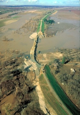
Today, these thousand-plus miles of levees are fortified by water pumps to keep the Delta from devolving into a swamp. But the levees remain extremely fragile. Some sections of the Delta have sunk more than 25 feet below sea level, making the now-tall, thin levees even more vulnerable. Some 170 significant breaches have been recorded since 1900. In 2004, the collapse of a 350-foot section of a levee resulted in a 12,000-acre flood that affected tens of thousands of people and caused more than $100 million in damages.
In 2008, a state-commissioned study predicted that in the event of even a moderate earthquake, as many as 70 levees would fail simultaneously, with 90 percent of the failures caused by liquefaction, a process that occurs when sand particles begin to slip and become extremely unstable.
But very little is really known about what an earthquake could do to the levees and the Delta peat they rest on. Peat samples from Brandenberg’s test site consist of five parts water to one part solid — a veritable sponge sopping-wet with water. The site is occupied by a cattle rancher who told the team that when his cows have calves, they sometimes go up on the levee to avoid sinking in the mucky ground.
 On Monday, Aug. 29, the researchers plan to power up the seismic shaker mounted atop a turdy timber frame embedded near the crest of its embankment. Starting with small shakes, they will incrementally increase the intensity over a span of time that could stretch to 24 hours or longer, eventually duplicating the forces of a strong earthquake. Simultaneously, they will track an assortment of data. Piezometers embedded in the peat will measure changes in water pressure under various seismic movements and levels of intensity. Accelerometers placed on top of and inside the embankment will measure ground movement.
One likely scenario, Brandenberg said, is that the levee will sink as the vibrations squeeze water out of the peat. “It could sink a few inches or a few feet,” he said. “If it’s a few inches, that could be fixed” by topping the Delta levees with additional fill. If the embankment sinks a few feet, that bodes for massive floods.
Another possible outcome, the researcher explained, is that “the entire levee would kind of punch into the ground and just push the peat out of the way.” While the top layer of peat, measuring about four feet thick, is dryer and stronger than the bottom layer of peat, it can easily be crumbled. The simulated earthquake “could break through this upper crust … and the whole thing might sink in. We don’t think that’s going to happen, but we don’t know,” Brandenberg said, adding, “That’s part of the fun of doing research.”
The researchers hope to complete their results by this spring, when they will present their findings to the U.S. Army Corps and the Department of Water Resources. But Brandenberg said, “We’ve got to talk to the people actually making the decisions” about the Delta, ranging from making major repairs to constructing an altogether new alternate water delivery system.
“Decisions are being made right now,” he said. “This is important. We don’t have a lot of time to figure things out.”
For more information and to view a video of the team building the embankment, go to the NEES website. The team’s data will also be posted here.
Learn more about Brandenberg’s work in podcasts of his Fiat Lux freshman seminar, “Hurricane Katrina as a warning about California’s water supply.”
Main Image: The research team built their own levee, using the same type of soil that Delta levees are made of. Inset Image: Levee breaches are common in the low-lying Delta, leading to extensive flooding.