University of California, Los Angeles
February 7—11, 2022
![]()


ONLINE SEMINAR
Commemorating the 50th Anniversary of the February 9, 1971 San Fernando California Earthquake
Organized by Lifelines 2021-2022 Conference Executive Committee, UCLA Samueli School of Engineering, and the City of Los Angeles Department of Water and Power (LADWP). Special guest speakers include Eric Garcetti (City of Los Angeles, Mayor), Steve Cole (LADWP, Engineering Section Manager), Jayathi Murthy (UCLA Samueli School of Engineering, Dean), Emily Carter (UCLA, Executive Vice Chancellor and Provost), Steve Bohlen (California Geological Survey, Head), and Thomas D. O’Rourke (Cornell University, Professor Emeritus).
February 9, 2021 at 12p.m. PST
Due to continuing impacts from the COVID-19 pandemic, the Lifelines 2021 Conference was rescheduled from February 2021 to February 7-11, 2022. One of the motivations for scheduling the original event in February 2021 was to mark the 50-year anniversary of the 1971 San Fernando earthquake, which was a seminal event in the history of Lifelines Earthquake Engineering. We still plan to mark the event anniversary with a special online program from 12-1 pm on February 9, 2021. We are pleased to cordially invite you to this event, which is jointly organized by the Conference Executive Committee, UCLA Samueli Engineering, and the City of Los Angeles Department of Water and Power.
The event will be an online seminar at noon on February 9, 2021, hosted by UCLA Samueli Engineering with presentations from Marty Adams (General Manager, City of Los Angeles Department of Water and Power), Steve Bohlen (Head, California Geological Survey), and Thomas D. O’Rourke (Professor, Cornell University). The topics of the seminars will relate to the 1971 event and progress in earthquake risk mitigation since that time. Hope you will join us. Register for the webinar.
![]()
![]() .
. ![]()

Replies to questions the moderators were unable to ask panel members during the webinar.
What about resilient and smart trenchless solutions to provide superior damage-resistance and real-time information about the state of (water) lifelines?
With the assistance of the Cornell Lifelines Large-Scale Testing Facility, we have been developing the next generation hazard-resilient infrastructure through large-scale testing and numerical modeling: https://lifelines.cee.cornell.edu/. Ten new pipeline and conduit systems have been developed and commercialized using a protocol of large-scale tests and fault-rupture experiments that define and confirm performance under extreme conditions of ground deformation. Next generation hazard-resilient infrastructure can withstand major seismic events and recover quickly from disruptions through the capacity of pipelines, conduits and cables to accommodate large ground deformation from earthquake-related fault rupture, liquefaction and landslides. In addition, the pipelines, conduits and cables can withstand ground movement caused by hurricanes, floods, tunneling, excavations and subsidence related to mining and dewatering.
Read More
How many main breaks within LADWP's service area were identified and repaired as a result of the 1971 earthquake?
About 800 repairs were made to the LADWP water distribution system pipelines
Is there a cross collaboration statewide among the various components of lifeline resiliency community, such as between transportation (e.g., bridges), utilities (water line, gas line), etc.?
There are collaborations across lifeline systems at different levels to improve community resilience. There are several examples in Northern and Southern California, Oregon, Washington and other states. We are not aware of any single comprehensive statewide initiative to coordinate all lifelines systems at all levels. However, the Oregon and Washington seismic resilience plans do provide initiatives for all lifeline systems to follow. More information can be found at these websites. (https://www.oregon.gov/oem/documents/oregon_resilience_plan_final.pdf, https://mil.wa.gov/asset/5bac1790e2d29).
Can we hear a summary of the nature and benefits of the structural health instrumentation programs, and their integration with other earthquake impact observations?
If we look at the full spectrum — earthquake preparations, early warning and recovery — the preponderance of effort has been, appropriately, on the first two parts. Efforts on recovery have focused to a large degree on emergency-response planning, communications and preparedness of emergency responders. Preparation is, and will forever be, an ongoing need as the public tends to forget, becomes complacent as the time between major seismic events grows, and denial and fatalism work against getting the public prepared.
Read More
Furthermore, the data from these sensors combined with established seismic networks will inform new approaches to seismic engineering and earthquake resilient structures, completing the cycle of recovery back to preparation.
Hazard resilient infrastructure also involves high performance sensors that include fiber optics and unmanned aerial vehicles (UAVs) using LiDAR and photogrammetric techniques, such as Structure from Motion (SfM). Fiber optics have been applied to pipelines crossing active faults and used to enhance the maintenance of subway tunnels. Complex hydraulic network models have been created for West Coast water supplies, such as those for Los Angeles and San Francisco, which are able to simulate water system response to earthquakes. Earthquake recovery will often utilize proven technologies where their combination is innovative and different. Just like a cell phone embodies proven technologies — phone messaging, internet, GPS, cameras, applications, etc. — it is not the individual technologies, but their integration that makes the cell phone innovative. It is innovation through integration that is assisting with earthquake recovery and serving as a model for community rehabilitation from all natural disasters.
Is there an early warning system of any type now?
The ShakeAlert Earthquake Early Warning System is working well and the system buildout and implementation of public and automated operation users throughout the Western states (CA, OR, WA) are expanding.
Read More
- Seismic sensor buildout is 2/3 complete in CA and half completed in OR and WA.
- The ShakeAlert system quickly determines the location and estimated magnitude and shaking intensity from an earthquake by analyzing the first shaking by sensors near the source.
- ShakeAlert data processing centers in Seattle, San Francisco Bay Area and Los Angeles Area are now fully integrated across the West Coast.
- USGS sends ShakeAlert messages over a set estimated magnitude to alert distribution partners who deliver the alert to people and necessary devices to protect the public, and trigger automated operations to reduce losses (slowing trains, open firehouse doors, close valves, etc.)
- In October 2018, ShakeAlert messages were officially made available to 60+ partner organizations for automated operations.
- In January 2019, the City of Los Angeles announced its cell phone app for delivery of ShakeAlert to LA residents. This was a test of the feasibility of a mass alert distribution technology. Much was learned from the ShakeAlert app and it was terminated the end of 2020 when other statewide apps became available.
- In October 2019, WEA (Wireless Emergency Alert system), QuakeAlertUSA and MyShake smartphone apps were successfully tested and became available for use in California.
- On March 11, the state of Oregon will announce the testing and use of the WEA system to deliver ShakeAlerts to the public and WA plans to follow sometime in the spring.
- Current technologies for mass notification via cell phones, TV and radio are generally not yet fast enough or able to handle the volume of messages needed for widespread, effective early warning, but USGS is working with state emergency managers and alert-delivery organizations to address this challenge. Public education is essential for people to take the proper action of “Drop, Cover and Hold On” during an earthquake.
- The public and organizations are encouraged to use multiple modalities to receive ShakeAlerts (PA systems, two-way handheld radios, etc.) and more devices are currently being tested and approved for use.
- People need to understand that they may receive an alert before, during or after shaking arrives at their location depending on their distance from the quake and the mechanism used to receive the alert.
- Protective action should be taken when shaking is felt or an alert received.
Overhead electric wires may be downed in an earthquake, posing a high risk of electrocution and fires. Does DWP have a Standard Operating Procedure for its network operators regarding if, when, where and how to shut off power?
LADWP has procedures in place to protect the electric grid and to promptly and safely restore service to our customers for both catastrophic events such as an earthquake or routine electric trouble events. These procedures place the highest priority on safety and operators are well trained on when and how to de-energize equipment.
The lifelines seem to cover publicly owned utilities. How do privately owned utilities, oil/gas enter the picture? How are the private operators preparing for a seismic event?
Lifelines are not limited to publicly owned utilities. Lifeline infrastructure systems are owned and operated by both public and private entities. Privately owned lifeline systems have prepared, and will continue to prepare, for earthquake events. The public and privately owned utilities coordinate their efforts where appropriate.
What are the initiatives to account for interdependencies between different infrastructures?
The NIST-FEMA Functional recovery report (https://nvlpubs.nist.gov/nistpubs/SpecialPublications/NIST.SP.1254.pdf) summarizes some ongoing initiatives and includes recommendations for the development of local lifelines councils to facilitate discussion and interaction among lifeline system organizations to better address collaborations.
Online Seminar Hosted by UCLA Samueli School Engineering
Agenda:
Welcome 12p.m. PST
Jonathan P. Stewart
Civil & Environmental Engineering, UCLA Samueli School of Engineering
Introduction
Jayathi Murthy
Ronald and Valerie Sugar Dean, UCLA Samueli School of Engineering
Remarks
Emily Carter
UCLA Executive Vice Chancellor and Provost
Presentation
Marty Adams
General Manager, LADWP
Presentation
Why California is Safer Because of the San Fernando Earthquake
Steve Bohlen, Head, California Geological Survey
Presentation
February 9, 1971: Birth of Lifeline Earthquake Engineering
Thomas D. O’Rourke, Professor Emeritus, Cornell University
Q&A
Moderated by Lifelines2021-2022 Conference Co-chairs:
Ertugrul Taciroglu, Chair, Dept. of Civil & Environmental Engineering, UCLA Samueli School of Engineering
Craig Davis, Ret. Waterworks Engineer, LADWP
Adjourn 1p.m. PST
Special Guest Speakers
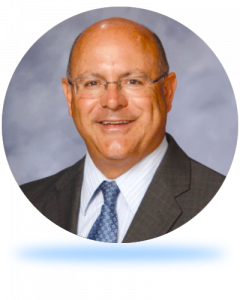 Marty Adams
General Manager
LADWP
 Steve Bohlen
Head
California Geological Survey
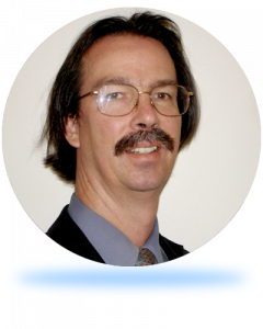 Craig Davis
Ret. Waterworks Engineer
LADWP
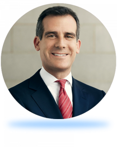 Eric Garcetti
Mayor
City of Los Angeles
 Jayathi Murthy
Ronald and Valerie Sugar Dean
UCLA Samueli School of Engineering
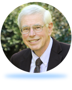 T.D. O’Rourke
Thomas R. Briggs Professor of Engineering
Cornell University
 Jonathan Stewart
Professor
UCLA Samueli School of Engineering

Conference Organizers

Collaborating Partners

Supporting Organizations
Sponsors
Platinum Sponsors


Gold Sponsors
Silver Sponsors


Bronze Sponsors
Coffee Break Sponsors
Exhibitors
